
Wildfire Risk Management
Information Today. Protection Tomorrow.
30 Day Community/County Wildfire Preparedness Program
An Affordable Community Wildfire Preparedness Program for Counties, Residents and Emergency Management Agencies

Why We Built It
More than a decade ago, our team developed mobile applications for disaster response, including damage assessment tools for the American Red Cross and FEMA mobile Incident Command System (ICS) applications used to rapidly collect and distribute critical emergency information.
Those tools helped communities respond after disasters occurred.
The WUI/PUI Property Owner Checklist for the Wildfire Preparedness Program was designed for something even more important:
Prevent Tragedy Before It Happens
Originally developed in 2015, the application enables property owners to document preparedness information, identify vulnerabilities, and complete corrective actions that can reduce wildfire risk before an emergency occurs. Today, as wildfires increasingly threaten communities across Colorado and the Western United States, we are making the system available once again.
What Residents Can Learn & Document
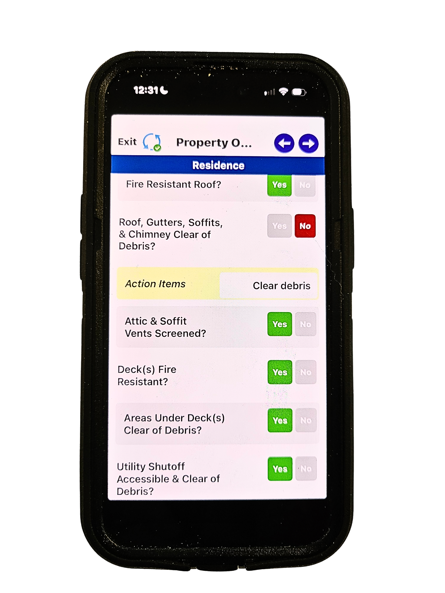
Using a simple mobile application available on Apple, Android, and Windows devices, residents can learn about and record:
✓ Property address signage visibility
✓ Access roads and emergency vehicle clearance
✓ Homes, structures, and outbuildings (adding home floorplan is optional)
✓ Livestock and animal information (prepare 3 days of feed & meds)
✓ Evacuation considerations
✓ At-risk residents requiring special assistance
✓ Property photographs and preparedness information
The system automatically generates a report highlighting action items that the resident can address during the preparedness campaign period.
Examples include:
Improving address visibility
Clearing vegetation and defensible space
Preparing evacuation plans
Documenting livestock needs
Identifying vulnerable household members so emergency managment can prepare
County 30 Day Risk Mitigation Program Year Long Benefit
Improve Preparedness
Residents beome active participants in wildfire risk reduction.
Strengthen Community Resilience
Encourage mitigation activities before disasters occur.
Support Evacuation Planning
Identify access issues, at-risk residents, and special circumstances.
Increase Situational Awareness
Provide actionable property-level intelligence for emergency management, fire departments, and sheriff's offices.
Complement Existing GIS Investments
The system exports data to existing GIS platforms while providing resident engagement and follow-up capabilities that GIS mapping systems alone were not designed to provide.
Return on Investment
FIRST: Protected People, Property, Pets and Livestock
Counties can launch a pilot program for approximately 100 households for about $2,300 in the first year.
A larger 1,000-resident campaign costs approximately $11,100, averaging roughly $11 per participating household.
For a relatively modest investment, counties gain:
Improved community preparedness
Enhanced evacuation planning
Documentation of vulnerable populations
Better property access information
Increased resident engagement
Valuable pre-incident intelligence
Compared to the potential costs associated with wildfire response, property damage, community disruption, and post-incident recovery, the program offers an affordable and scalable approach to risk reduction.
Pricing:
The App: The one-time cost of the app for public agencies is $575.00. The application can also be branded and customized to meet county-specific needs for an additional software development fee.
The License:The county license, which includes access to the data portal displaying property locations and reports, is $28.00 per month or $308.00 annually. The license includes checklist follow up calendar, unlimited reports, mapping, photo storage. Additional apps, including ICS forms, damage assessment, rapid emergency response can also be added to the system if desired.
One Time 30 Day Resident App Licenses are priced based on volume and are valid for the recommended 30-day WUI/PUI Checklist campaign. Contact us for volume pricing and discounts, starting at $15.00 each with pricing descending with volume.
A live Situational Analysis Dashboard can also be developed for an additional fee if it is determined to be a practical tool for the county. Pricing depends on the size and scope of the data but starts at a one-time development fee of $575.00, with monthly county personnel user licenses beginning at $25.00 per user, discounted based on volume.
As of August 6, 2026, more than 235,000 acres have burned, hundreds of homes have been lost, and firefighters have made the ultimate sacrifice protecting lives, property, and communities.
The reality is clear: wildfire preparedness can no longer begin when smoke appears on the horizon.
It must begin long before an emergency occurs.
The MapToTrack® Property Owner Wildland-Urban Interface and Prairie-Urban Interface (WUI/PUI) Checklist helps counties engage residents in proactive wildfire preparedness while providing emergency management agencies with valuable pre-incident information that can support planning, mitigation, evacuation, and response operations.
How the County Program Works
The county establishes a readiness campaign, typically lasting 30 days.
Residents receive temporary licenses that allow them to complete the WUI/PUI Checklist and submit information through their mobile devices.
Information is securely uploaded to a county-managed portal where emergency management personnel can:
Monitor participation
Review property preparedness
Track action items
Identify vulnerable populations
Improve situational awareness
At the conclusion of the campaign, resident licenses are deactivated and reissued for future preparedness efforts.
The county license remains active to support planning and emergency operations.
Benefits
The result is a more complete picture of a property before emergency personnel ever arrive on scene.
Preparedness often fails because it feels overwhelming. We built this platform to eliminate that barrier. The application guides users through a simple process that allows them to capture the information emergency managers and first responders need most, without requiring technical expertise or specialized training.
In short, it is designed to be practical, intuitive, and effective.
For counties, the benefits are equally compelling.
The platform provides a cost-effective way to strengthen community preparedness while improving situational awareness. By collecting critical property information before an incident, emergency management teams can better understand community vulnerabilities, support planning efforts, and enhance communication with residents.
When wildfire conditions escalate, having access to accurate information about addresses, property access, structures, livestock, and vulnerable populations can help support more informed decision-making.
Just as importantly, the application transforms residents from passive recipients of emergency information into active participants in preparedness.
Wildfire resilience is not created by government agencies alone. It is built through partnerships between residents, local leaders, emergency managers, and first responders. Every address sign made more visible, every access road documented, and every at-risk resident identified contributes to a stronger and safer community.
As wildfire threats continue to evolve, communities need solutions that are practical, affordable, and easy to deploy. We believe preparedness tools should empower residents while providing meaningful value to the agencies responsible for protecting them.
That belief inspired this application eleven years ago.
It is the same belief driving its return today.
Because wildfires don't stop at fence lines.
And preparedness shouldn't either.
Our Process
-
App Modification
The app can be modified to meet the exact needs of the county or municipality.
-

Collaborate
We want to be sure the App, Checklist/Report and optional Situational Analysis/Analytics Dashboards meet the environment you work in.
-

Adapt as Needed
Active resident licenses are deactivated after the 30 day program to conserve budget. We recommend the county license stay active year round.
-

Deliver with Confidence
When we deliver, it’s not just a finished product—it’s a solution you can trust, backed by real care and effort.